Walk with us through spontaneous and unapologetic adventures. Join us in budget minded Sprinter DIY successes and failures: Sleeping 4 in a Sprinter 144.
Rambling Footsteps are participants in the Amazon Services LLC Associates Program, an affiliate advertising program designed to provide a means for sites to earn advertising fees by advertising and linking to Amazon.com and affiliated sites.
CD’s PCT thru hike trail journals are interesting. The common themes are food, water, dust, heat, sleeping, walking, and people. It all seems pretty basic really.
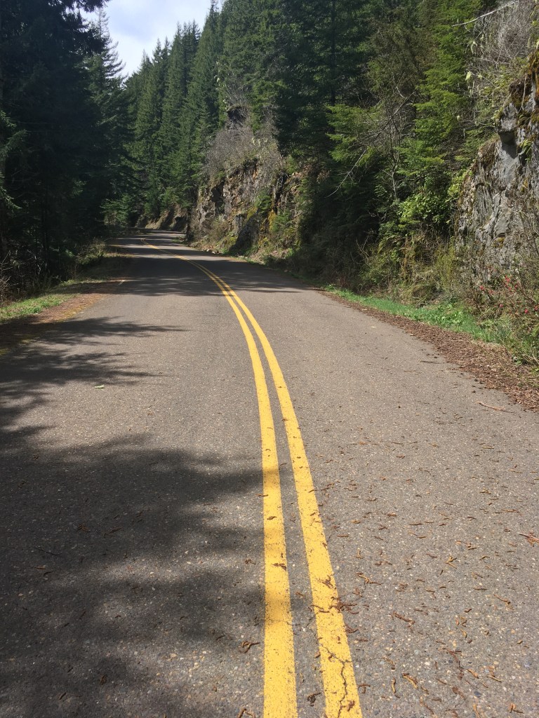
Meadow track to Warner Springs. #PCT
Warner Springs offered CD an introduction to the thru hiking community. He left town with a group of 15 or so hikers and they stayed together through a hot springs North of Lost Valley Road, I think.
Looks like Truffula Trees. #PCTHot Springs North of Warner Springs. #PCT#PCT
They rinsed clothes and soaked their joints. Local characters gathered there as well included a local stripper and a guy that carried his pipe, which he preferred to light with a magnifying glass, on a string around his neck.
CD and the pipe guy went to town and returned with watermelon. Apparently watermelon is not common on thru hikes and it was a big hit!
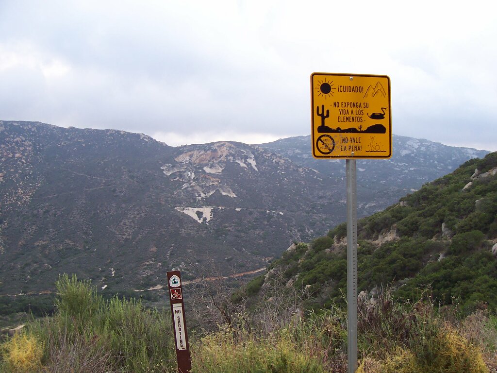
Phlox in the burn. #PCT
That time that CD left me on the road in order to give some thru-hikers a lift to town.
I have had only one experience on the PCT in southern California. CD and I were driving from Palm Dessert to San Diego. As we approached the PCT, I could feel CD’s excitement. I could tell that he really wanted to be a trail angel for someone.
We rolled over a hill in our Honda Civic hatchback and saw two hikers waiting for a ride to town. CD pulled over before he could even tell me his plan. Next thing you know, the two hikers, their packs, and CD were out of view and I was standing on the edge of the road.
It was me, tumbleweed, and the hundreds of rattlesnakes that obviously lived there.
I was out of place in clean clothes, sandals, and with my purse over my shoulder. Another set of hikers showed up from the South. They stopped to chat. They had met on the trail in 2004, did not complete their hikes that year, but went on to get married. On the trail again, they were hoping to complete it this time. I was new to the secret code of “trail names” but we were able to figure out that they had been on the trail with CD in 2004. They had crossed paths in approximately the same section of the trail that we were on then. I thought of this today while reading their names in CD’s trail journal.
A short time later, they got picked up by a passing car. I reached back to the old fashioned communication means of my youth and asked the hikers to send CD my way if they happened to see him hanging around town. I stood there, without a cell signal, waiting for CD.
More than an hour later he came back for me. It was fine. I was fine but I like to remind how about how he deserted me on the edge of the road during a hot day in the desert and didn’t pick me up until dusk.
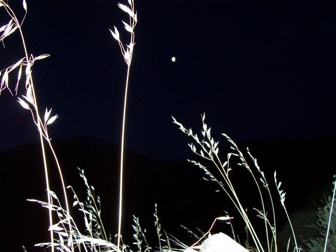
This came out beautifully by accident. I love the frame of the moon. #PCT
CD’s trail journals are interesting. They read like bullet points in places. Many days have similar themes. These include food, water, dust, heat, sleeping, walking, and people.
Meadow track to Warner Springs. #PCT
From what I can gather, Warner Springs offered an introduction to the thru hiking community. He left town with a group of 15 or so hikers and they stayed together through a hot springs North of Lost Valley Road, I think.
Looks like Truffula Trees. #PCTHot Springs North of Warner Springs. #PCT#PCT
They rinsed clothes and soaked their aching joints. Local characters were gathered there as well. There was a local stripper and a guy that carried his pipe, which he preferred to light with a magnifying glass, on a string around his neck.
CD and the pipe guy went to town for provisions and returned with fresh fruit for everyone. Watermelon was a big hit. Apparently, watermelon is not a common trail provision.
Phlox in the burn. #PCT
I have had only one experience on the PCT in southern California. CD and I were driving from Palm Dessert to San Diego. As we approached the PCT, I could feel CD’s excitement. I could tell that he really wanted to be a trail angel for someone.
We rolled over a hill in our Honda Civic hatchback and saw two hikers waiting for a ride to town. CD pulled over before he could even tell me his plan. Next thing you know, the two hikers, their packs, and CD were falling out of view as I stood on the edge of the road. It was me, tumbleweed, and the hundreds of rattlesnakes that obviously lived there.
I felt and looked out of place in clean clothes, sandals, and with my purse over my shoulder. Another set of hikers showed up from the South. They stopped to chat. They had met on the trail in 2004, did not complete their hikes that year, but went on to get married. They were on the trail again, hoping to complete it this time. I was new to the secret code of “trail names” but we were able to figure out that they had been on the trail with CD in 2004. They had crossed paths in approximately the same section of the trail that we were on then. I thought of this today as I read their names in CD’s trail journal.
A short time later, they got picked up by a passing car. I reached back to the old fashioned communication means of my youth and asked the hikers to send CD my way if they happened to see him hanging around town. I stood there, without a cell signal, waiting for CD.
More than an hour later he came back for me. It was fine. I was fine but I like to remind how about how he deserted me on the edge of the road during a hot day in the desert and didn’t pick me up until dusk.
This came out beautifully by accident. I love the frame of the moon. #PCT
4/28/2004 was the first day of CD’s Pacific Crest Trail thru hike. April 28 is also my birthday, so we celebrate.
He kept a trail journal and has offered it to me. This is just the beginning.
#pct #pacificcresttrail
Transition to life on the trail
I know very little about his time on the PCT. The first few weeks were a time of transition and learning. He went from hiking with a friend to hiking alone. He re-organized his pack and overhauled his food plan.
Prior to being on the trail, he imagined walking and walking just to see what was over the next hill. The people and relationships that make up the trail were not really part of the plan.
Human connection
Walking over 2500 miles by yourself in order to better appreciate human relationships seems counter-intuitive. In 2020, it is also an interesting topic in light of physical distancing in the face of pandemic.
CD tells me that he experienced his first trail magic just a few days into his hike.
#pct #pacificcresttrail
Trail Magic, Pacific Crest Trail Style
I was hiking through the hundred-plus degree desert sun and contemplating how much water I didn’t have. As I was reluctant to hike too far off trail for water and was pretty sure I could make it to the next source, I laid down on the side of a dirt road and put my feet up on an embankment trying to make my own shade.
Despite the heat, a family was settling in for a picnic up the road. Within a short time, the father came up and asked me where I was hiking. He was quite excited to learn that I was, indeed, on my way to becoming a PCT through-hiker He gave me water, fruit, and Gatorade. It was just the sign that I needed to let me know that I was on the right path.
With this, CD had his first glimpse of how much larger the thru hike was than just the trail alone.
He went on to Warner Springs, feeling lonely but not as thirsty as he may have otherwise been. Fellow hikers offered him a room to share. Being early in the trail, there were more questions than answers.
Self Reflection on the Pacific Crest Trail
How fast should I hike? When and for how long should I rest? How much should I interact with people? What was my larger goal? Was there supposed to be a larger goal?
It sounds like all of these questions were a collective work in progress during the next four months.
So, every April we celebrate CD’s PCT kick-off anniversary.
In 2020, lets walk around the block and see if we find some trail magic. I bet we will.
#pct #pacificcresttrail#pct #pacificcresttrail
Please follow our blog to hear more about CD’s hike and our other adventures.
I met CD in 2006. He thru hiked the PCT in 2004. His first day on the trail was April 28. I remember it because it also happens to be my birthday. At this point, I advocate celebrating the anniversary of his first day on the PCT along with my birthday.
He kept a trail journal and has offered it to me. This is just the beginning.
#pct #pacificcresttrail
I know very little about his time on the PCT. He has told me that the first few weeks were a time of transition and learning. He went from hiking with a friend to hiking alone. He re-organized his pack and overhauled his food plan.
He told me that prior to being on the trail, he imagined walking and walking just to see what was over the next hill. He underestimated the people and relationships that make up the trail.
Walking over 2500 miles by yourself in order to better appreciate human relationships seems counter-intuitive. It is also an interesting topic in light of the past 6 weeks of physical distancing in the face of pandemic.
CD tells me that he experienced his first trail magic just a few days into his hike.
#pct #pacificcresttrail
He states: I was hiking through the hundred-plus degree desert sun and contemplating how much water I didn’t have. I had been reluctant to hike too far off trail for water and was pretty sure I could make it to the next source. I laid down on the side of a dirt road, put my feet up on an embankment, and tried to make my own shade.
Despite the heat, a family was settling in for a picnic up the road. Within a short time, the father came up and asked me where I was hiking. He was quite excited to learn that I was, indeed, on my way to becoming a PCT through-hiker He gave me water, fruit, and Gatorade. It was just the sign that I needed to let me know that I was on the right path.
With this, CD had his first glimpse of how much larger the thru hike was than just the trail alone.
He went on to Warner Springs, feeling lonely but not as thirsty as he may have otherwise been. Fellow hikers offered him a room to share. Being early in the trail, there were more questions than answers. He wondered: How fast should I hike? How long should I rest? How much should I interact with people? What was my larger goal? Was there supposed to be a larger goal?
It sounds like all of these questions were a collective work in progress during the next four months.
So, happy PCT kick-off anniversary CD. Lets walk around the block and see if we find some trail magic. I bet we will.
Its 2020 and CD has been working on the van while social distancing. It was half taken apart but still put together enough for a day trip. I decided that today was the day that we would break out of isolation.
I woke up and quickly packed snacks, jackets, and even travel games. CD put the head liner back in the van and used the shop vac to touch up the interior. The kids were buckled in and I was choosing our road music . Then, our battery was dead.
We don’t know why it was dead. The interior lights had been disconnected while CD was working. Does anyone know if the electric step could drain the battery over time? In any case, we don’t know why it was dead. We tried to jump it with our mini van but didn’t have any luck.
We changed our plan, put everything in the Sienna and headed to Mary’s Peak. We were sure it was closed and it was. The road was gated 5 miles or so from the peak. There were 4 or 5 cars parked at the trail head near the gate. We felt good about going for a walk here in terms of social responsibility in the face of the pandemic and opted to avoid the trail and duck the gate.
It was a great choice. The road was empty. We walked for a couple of hours. The kids smiled more than they have in weeks. They kicked rocks, raced imaginary dogs, built pretend fires, and fetched sticks for each other.
social distancing. Mary’s Peak, Oregon
This was a day like I used to have when I was running fifty miles per week. There were endless things to see that I never noticed from my car. Everything was interesting and new. An owl seemed to be hiking with us. We didn’t see it but its calls were unmistakable. The trees were greener, the sun was warmer, and even gun shots from the shooting range sounded nice.
We started our hike on the road at about noon. When we returned at nearly 3:00, the parking area was overflowing with cars. As a health care worker, I immediately felt guilty about going out during these times. Then I remembered that we haven’t gone out since this March 12, 2020 when we went skiing.
Today, we only saw one other family walking on the road and we hugged our respective edges when we passed. We didn’t get near anyone in the parking lot. We ate snacks in our car. I would have felt horrible if we had been on a single track trail walking past all of the people that arrived in all of those cars.
We were lucky. Walking the road was a great choice for us and we were able to enjoy it while still feeling like we were doing the right thing.
social distancing
Back to working on the Van.
Tonight, as I write this, the Sprinter battery is charged and all is well. We had been trying to jump it using 12 gauge cables and we needed more power. When we got home from Mary’s Peak, our neighbor tossed us his jumper cables from a socially responsible distance while standing on his homemade pickle ball court. By the time the kids and I sat down for dinner, CD was busy drilling holes in 80/20.
I look forward to taking the Sprinter the next time time we break out of home isolation.
Do you dream about sleeping among the granite rock walls of the Yosemite valley? Have you heard of Camp 4?
Yosemite is impressive and beautiful.
We arrived in CD’s Honda civic. We had come from Colorado via Utah, Nevada, Southern California, and Highway 101. The mountains were a welcomed site. We were road weary and our legs were begging to hike all day.
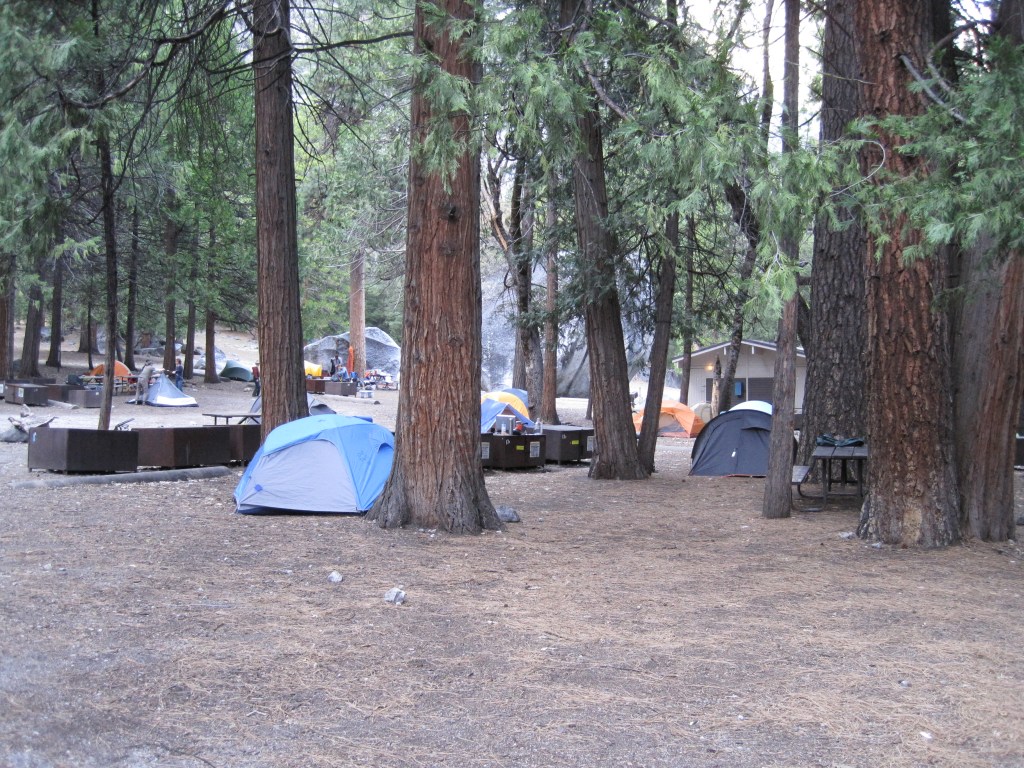
We rolled into Camp 4. I can’t remember if we were seeking Camp 4 or if we just needed somewhere interesting to camp.
Welcome to Camp 4, Yosemite
Camp 4 is a campground and a community. It is a lifestyle choice than a housing choice and this is obvious when you are there. It is a famous home base for climbers.
The cost was $6 per person per night. There are 30 some walk – in sites. There are rocks for bouldering, granite mountain sides for climbing, and trail heads for hiking.
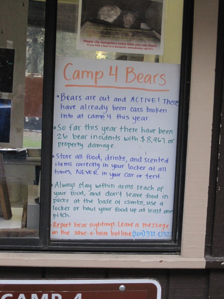
We were greeted with a list of rules. You must remove all food from your car and place in designated lockers. Camp 4 is loved by bears almost as much as by climbers.
We followed all of the recommended procedures. I cleaned the car, used the bear lockers, kept a clean campsite, and properly disposed of my dish water.
Camp 4, Yosemite
I convinced CD to use our largest tent. Who knows why we packed this way but we had CD’s sleeping tarp from the PCT, a new backpacking tent, and my old six person tent. It seemed logical that I would be less likely to be mauled by a bear in a six person tent than in a two person tent. CD didn’t agree but was kind enough to go a long, however.
camp 4, Yosemite. It is quiet in the afternoon.
Bears and Messy Campsites
The bears showed up at dusk, right on schedule. You could hear the classic: “hey bear” and “get out of here, bear”. Neither the bears nor the campers were particularly concerned.
The campground was relatively rowdy and a bit messy. Chip bags and beer cans were rolling around. Nobody really cared. Everyone was happy. I admit feeling a bit judgmental of the other campers food storage habits.
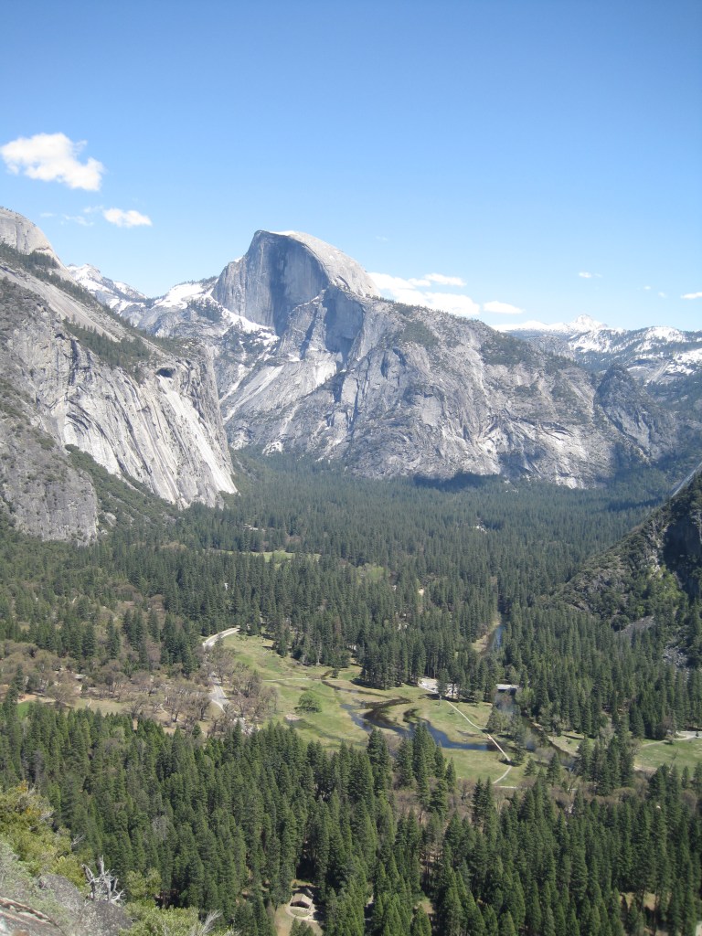
We passed by tons of climbers on our way to the trail.
A few hours later, the climbers from Camp 4 were below us and this was the view we found.
The view is spectacular, as you can see
Ultimately, I slept with one eye open but still felt rested. I reaped the benefits of being surrounded by free-spirits. They were having fun and it showed.
It is unlikely that I will stay at Camp 4 again since they don’t allow sleeping in the parking lot and the sites are not accessible to our van. If we sell the van, I will likely be too old and spoiled to sleep on the ground in Camp 4. I guess you never know.
As John Muir said: “And into the forest I go, to lose my mind and find my soul”.
Please check out our blogs for other National Park adventures.
Do you dream about sleeping among the granite rock walls of the Yosemite valley?
Yosemite is impressive and beautiful.
We arrived in CD’s Honda civic. We had come from Colorado via Utah, Nevada, Southern California, and Highway 101. The mountains were a welcomed site. We were road weary and our legs were begging to hike all day.
We rolled into Camp 4. I can’t remember if we were seeking Camp 4 or if we just needed somewhere interesting to camp.
Camp 4 isn’t just a campground, it is a community. It is more of a lifestyle choice than a housing choice. It is a famous home base for climbers and is even listed on the National Register of Historic places.
It was $6 per person per night. There are 30 some walk – in sites. There are rocks for bouldering, granite mountain sides for climbing, and trailheads for hiking.
We were greeted with a list of rules. You must remove all food from your car and place in designated lockers. Camp 4 is loved by bears almost as much as by climbers.
We followed all of the recommended procedures. I cleaned the car, used the bear lockers, kept a clean campsite, and properly disposed of my dish water.
I convinced CD to use our largest tent. I don’t know why we packed this way but we had CD’s sleeping tarp from the PCT, a new backpacking tent, and my old six person tent. It seemed logical that I would be less likely to be mauled by a bear in a six person tent than in a two person tent. CD went along with it.
The bears showed up at dusk, right on schedule. You could hear the classic: “hey bear” and “get out of here, bear”. The bears didn’t seem concerned by this and neither did the campers.
The campground was relatively rowdy and a bit messy. Chip bags and beer cans were rolling around. Nobody really cared. Everyone was happy. We passed by tons of climbers on our way to the trail.
A few hours later, the climbers from Camp 4 were below us and this was the view we found.
Ultimately, I slept with one eye open but still felt rested. I reaped the benefits of being surrounded by free-spirits. People were having fun and it showed.
Will I stay at Camp 4 again? It is unlikely. They don’t allow sleeping in the parking lot and the sites are not accessible to our van. If we ever sell the van, I will likely be too old and spoiled to sleep on the ground in Camp 4. – but who knows.
As John Muir said: “And into the forest I go, to lose my mind and find my soul”.
It is spring in Utah when the rivers are running high, the sun is shining, and the roads are full of Colorado license plates. There is no better way to celebrate the end of ski resort employment than to leave the high country in favor of the red rocks of Utah.
I started this tradition prior to meeting CD and we continued it together every May until we moved from Colorado. Utah has so much to offer that I don’t even know where to begin. While the order is irrelevant, I will start southwest, go roughly northeast but stay south of I-70 and then end southeast near the four corners.
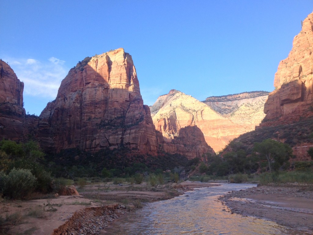
Zion National Park is my favorite, hands down. We have been there over and over. We have hiked end to end, climbed its peaks, and waded through its slot canyons. Its red rock is made more brilliant by the Virgin river and green trees. The proximity to the town of Springdale with its cold drinks and hot breakfast doesn’t hurt either.
The Desert Pearl, in Springdale. If you are looking for a break from camping, this place is unlikely to disappoint.
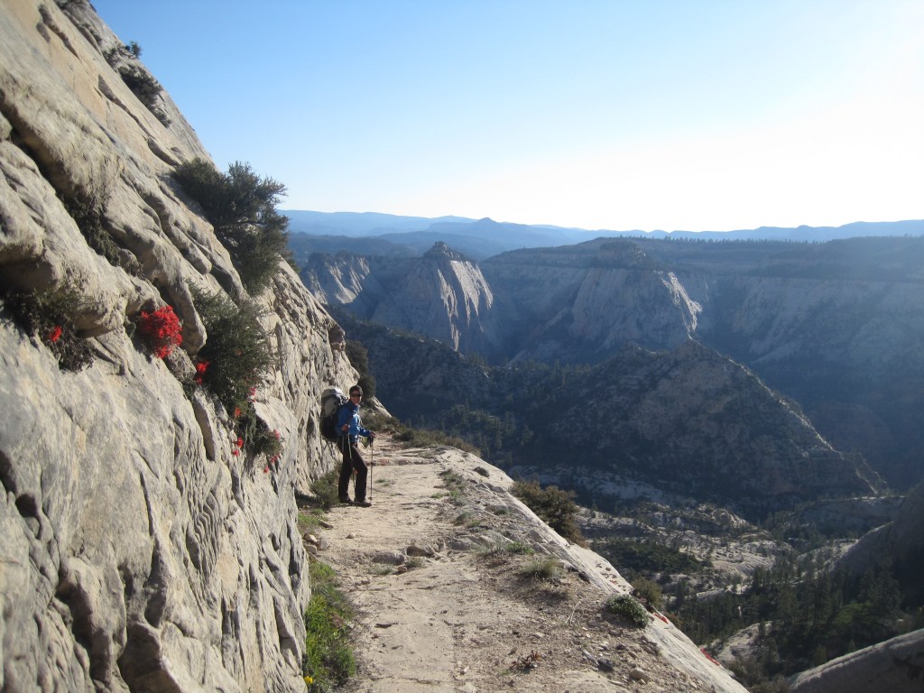
Angel’s Landing is its most well known hike. It starts with switchbacks called Walter’s Wiggles. It is well known that I love switch backs for the exercise alone. There is no better way to start the day.
It isn’t until after the switchbacks that this hike really separates itself from the rest. Angel’s landing is no joke in terms of exposure and drop offs.
The trail narrows to one way. There is a chain link railing. You are exposed to the depths of the valley floor, more so in some places than in others.
My first time up Angel’s Landing was with my brother. Making it to the top was a rush. Making it back down alive was even better. The next time was with CD. The rush was not as great but the feeling of relief after was even greater. The third time was with CD again. The steps felt more narrow and the valley floor seemed a bit further than before. With that, I decided that three times up Angel’s Landing is likely enough for me.
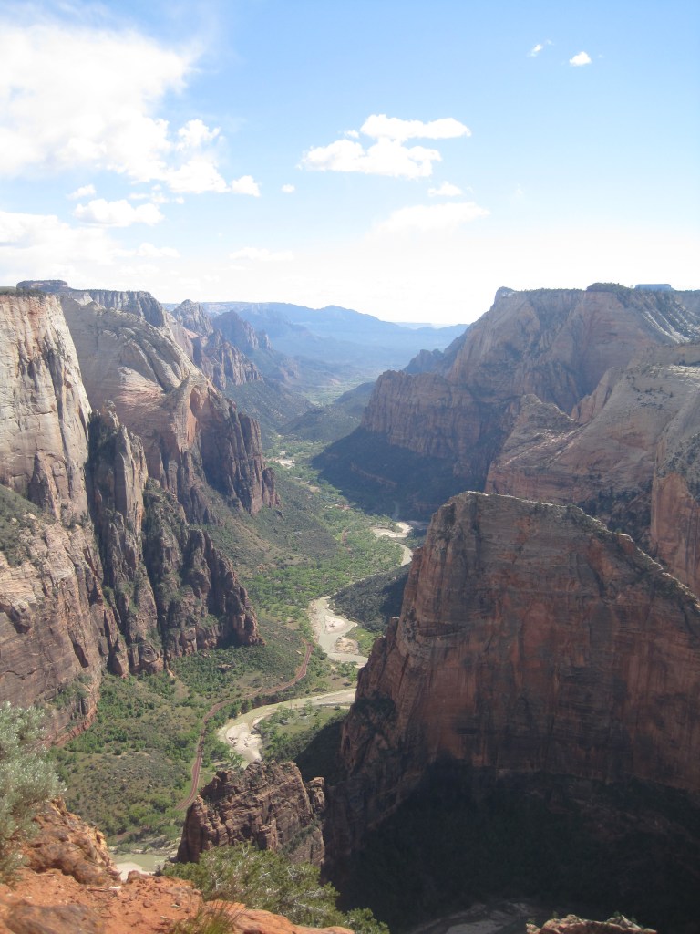
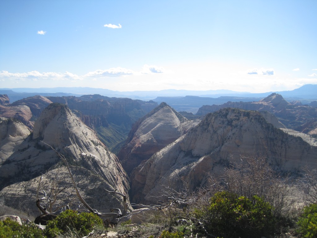
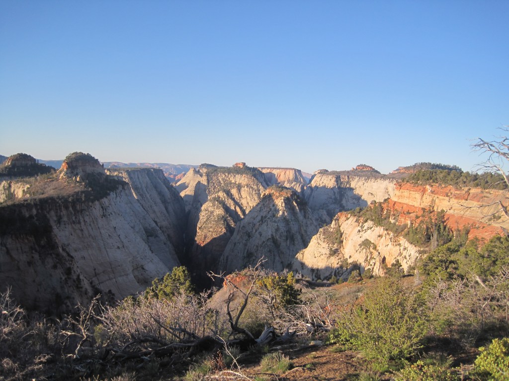
We looked for other routes with bigger and better views. Observation Point hit the mark. It is a more physically challenging and longer hike. It climbs 2100 feet and rises 700 feet above Angel’s Landing.
Zion, UtahAngel’s Landing
Zion, Backcountry
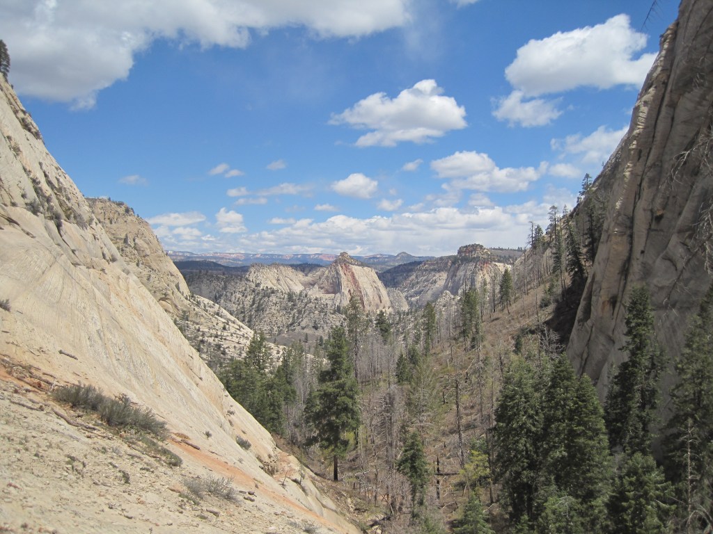
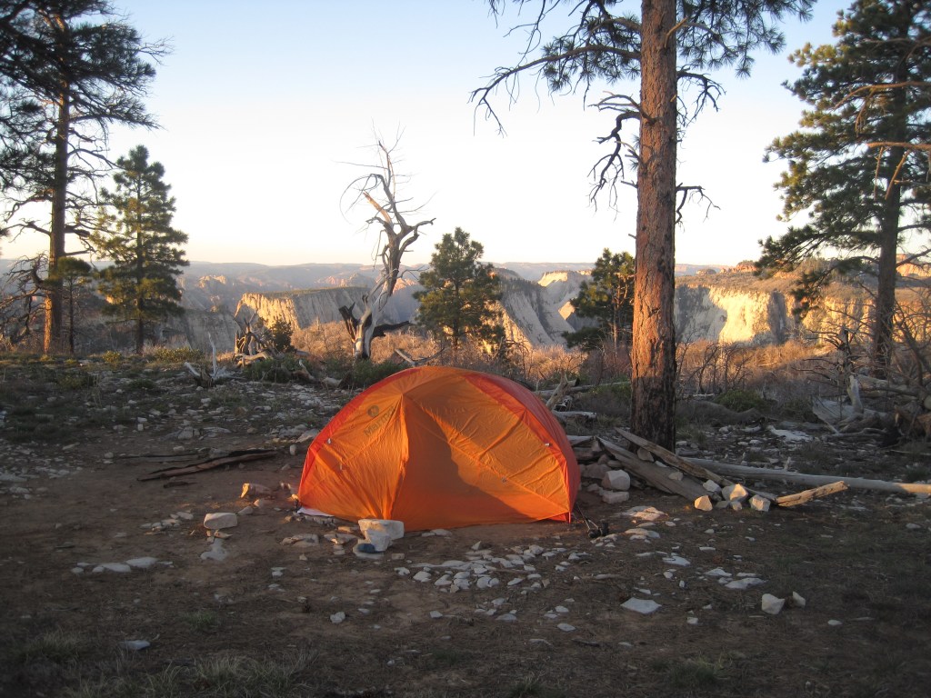
Back country sites are accessible from the main entrance. Below is the view from our camp site along the West Rim Trail. It is worth noting that we started the hike with a crowd headed to Angel’s Landing. As soon as we turned away from that route, we were on our own. It was super windy and we were surrounded by dead trees. We woke up in the morning to distance runners coming down the rim trail.
Zion, Kolob Canyon
Kolob Canyon is Zion’s less known North entrance. It offers day hikes and backpacking trips with few other people around. Our back country site was in an old river bottom. Much of the hiking was in loose sand. Snakes loved it.
If you have seen the wide open spaces of Zion and are ready for a change, the Narrows may be your next stop. Do your research. Be informed. Watch the weather. These slot canyons are beautiful and it is good to pay attention if you plan to do much exploring. CD met a friend there for his fortieth birthday and they didn’t end up finishing their chosen route because of flash floods.
From Zion, you can get to Bryce Canyon in a short day. It is higher and cooler. This is great in the hot months and not as great in the early spring. It is smaller and more compact. The Hoo-doos are unique and impressive. I tend to pass through Bryce westbound to Zion or eastbound to Capital Reef but CD is a fan of the views at sunrise. He also has told me good things about a coin operated shower at the general store.
Apparently, he has a great memory of enjoying a post-hike beer from the general store while sitting on the lodge porch at sunset after a hot shower.
I rarely hear people talk about Capital Reef but we have found it to offer great hiking, impressive rock formations, and amazing views. I don’t recommend hiking there if you are hoping to meet people and chit chat over hand fulls of trail mix. The trails are largely empty.
At this point it is worth mentioning the San Rafeal Swell. It offers slot canyons with campsites tucked away on BLM land. My advice: Go there, if you have time. Bring your own shade. Do what I did and go with someone that has been there before – hopefully someone proficient at navigating slot canyons. Goblin Valley State Park is near by and may be a better choice if it is your first time in the area.
The price was right but shade was sparse. This was our route to enter the slot canyon.
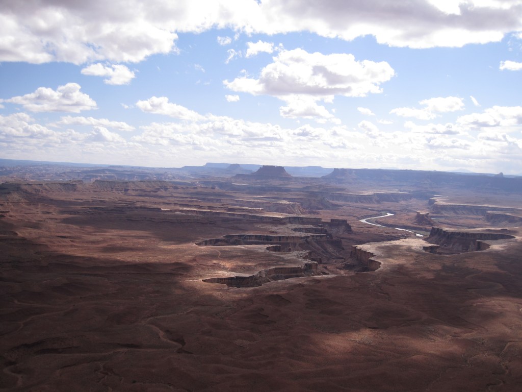
Canyonlands is easier to access from Moab than from the Southwest. The views are endless. The hiking is interesting and fun. Regions of the park have names like Needles, Island to Sky, and The Maze. Mountain biking the White Rim Road loop is popular and it is on my to-do list for sure. We have not camped in the back country but we have camped just outside the park and there are beautiful starry skies.
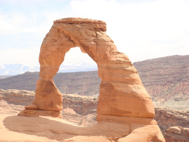
Arches is a straight shot from I-70 and is complimented by it’s close relationship with Moab. The Colorado River provides contrast to the red rock backdrop. The La Salle mountains rise up with snowy peaks and provide further contrast and depth to the scenery.
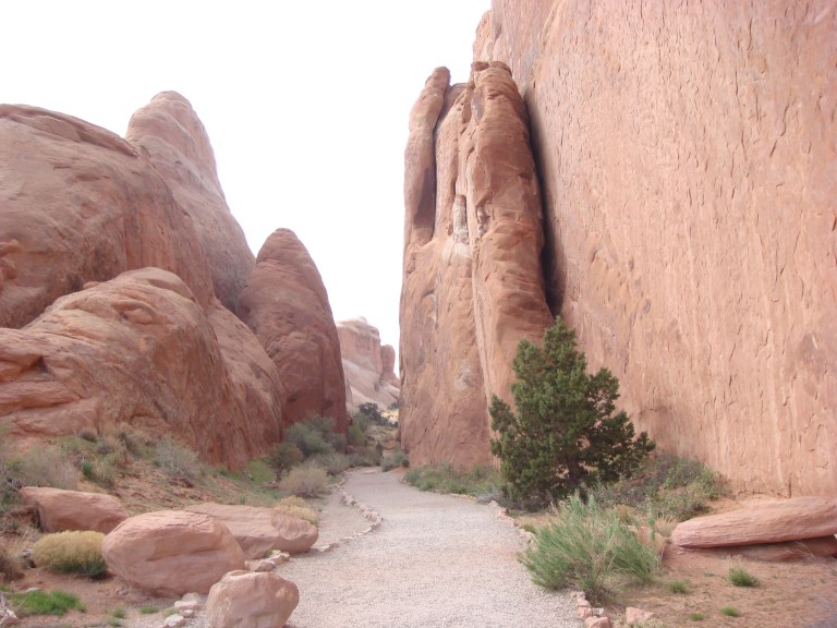
Moab is like the old west meeting a trendy art gallery. The restaurants and shops are full of personality and there are tour companies to suite everyone’s needs. You can sign up for 4 x 4 tours, mountain biking, hiking, river rafting, paddle boarding, horse back riding, and pretty much anything else you can imagine.
While I cannot speak to the tour companies, I can attest to the hiking and camping. Hikes range from easy to more difficult. Arches is typically one of the more crowded Utah parks but for good reasons. Campsites are dotted along the river banks and range from rustic and isolated to developed and popular. I recommend them all!
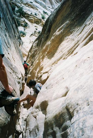
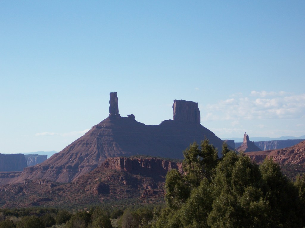
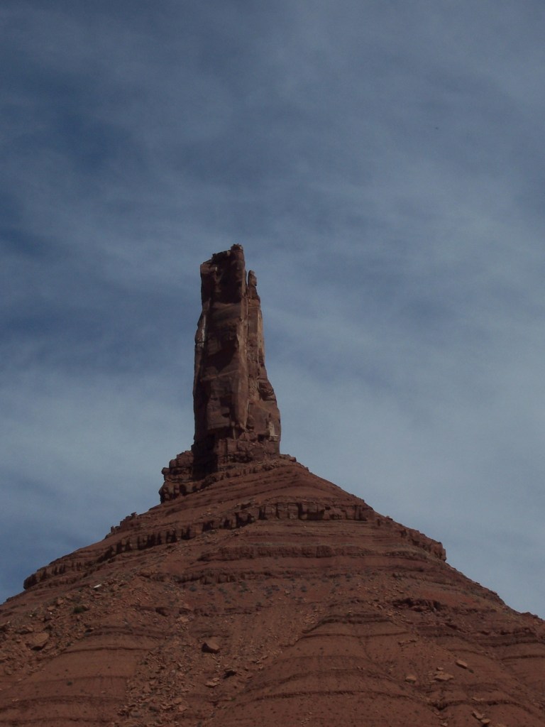
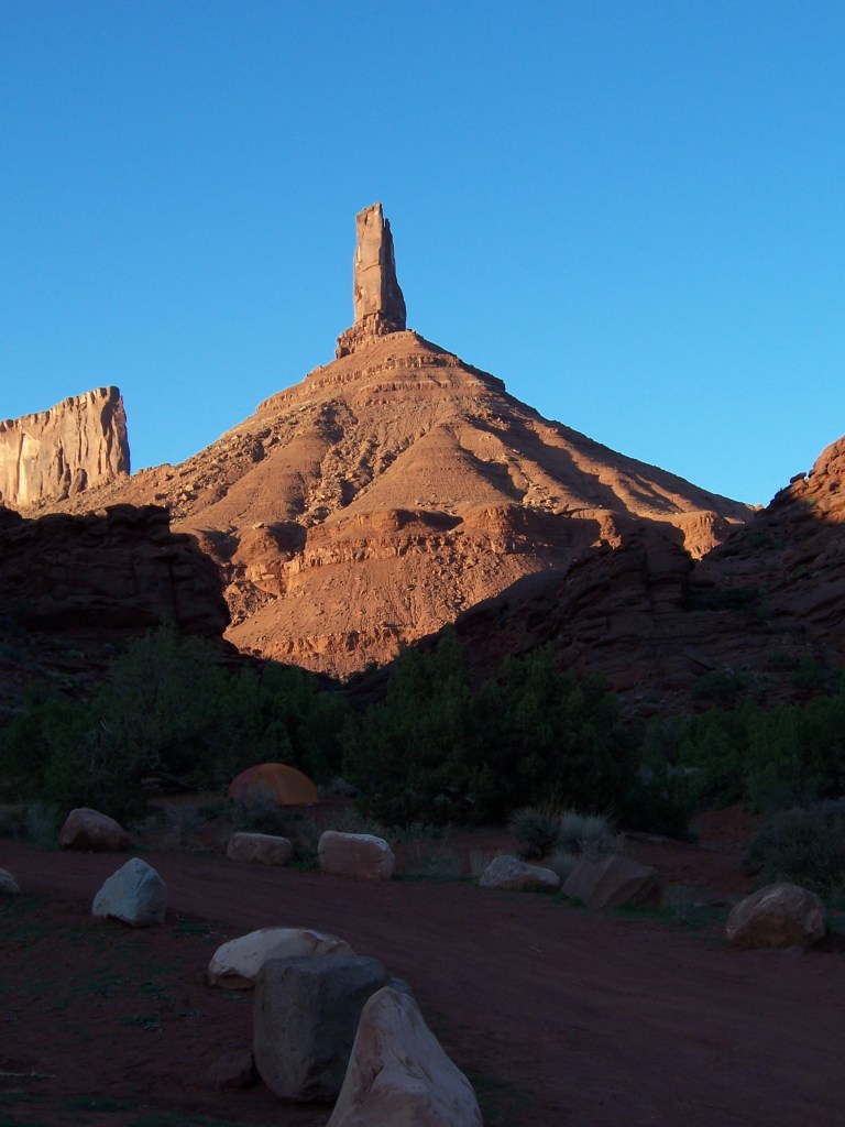
Just a bit East and on BLM land, you will find Castleton.
Castleton Tower from above the parking lot
Pretty much everyone was there to climb. CD climbed with friends while I hiked and then read a book at the campsite. It was great. Everyone was happy.
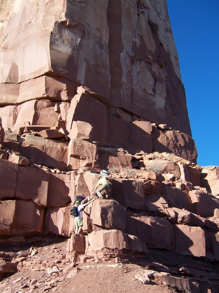
Hiking up to start the climb. It looked taller in person. This is where I turned around and CD went upOur tent – in the shade!
If you don’t climb, it is still beautiful to see but you will likely enjoy camping somewhere else more than camping here. This was packed with climbers and surrounded by wide open desert.
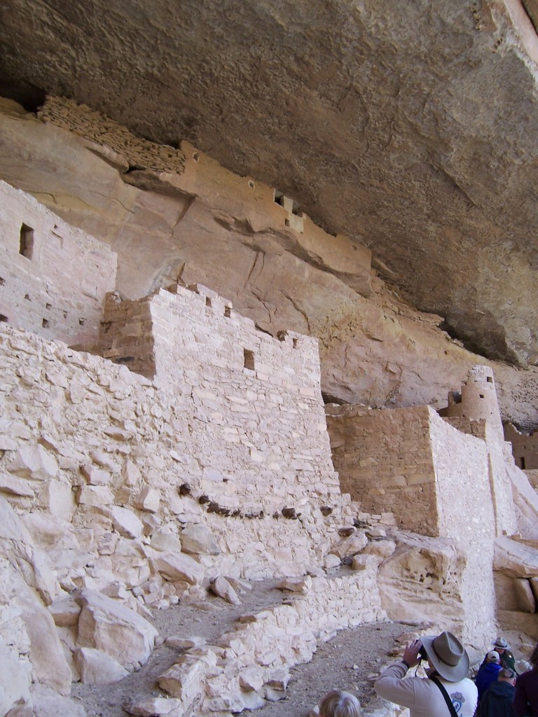
Dropping down to the four corners, you can hop into Mesa Verde. While the cliff dwellings are interesting and worth seeing, you may find a bit of crowd. My favorite feature is its proximity to Durango. Check out the Silverton Narrow Gauge railway and head North to Ouray or East towards Pagosa Springs on your way out of town.
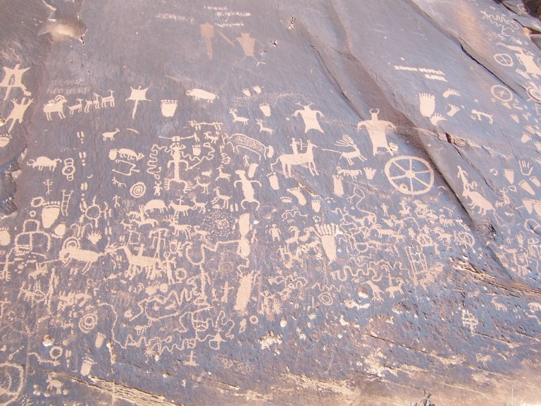
These petroglyphs are at Mesa Verde, Utah. You can see similar markings along I-70 just West of 191.
I could keep going on and on about Utah but will stop myself here for now. Utah is dense with natural wonders. I recommend going there and seeing it first hand.
Red rock dust from ten years ago still stains my hiking boots. Seeing it makes me smile.
Please consider following our blog for more adventures.
You know it is spring in Eastern Utah when the rivers are running high, the sun is shining, and the roads are full of Colorado license plates. There is no better way to celebrate the end of seasonal ski resort employment than to leave the high country in favor of the red rocks of Utah. I started this tradition prior to meeting CD and we continued it together every May until we moved from Colorado. Utah has so much to offer that I don’t even know where to begin. While the order is irrelevant, I will start southwest, go roughly northeast but stay south of I-70 and then end southeast near the four corners.
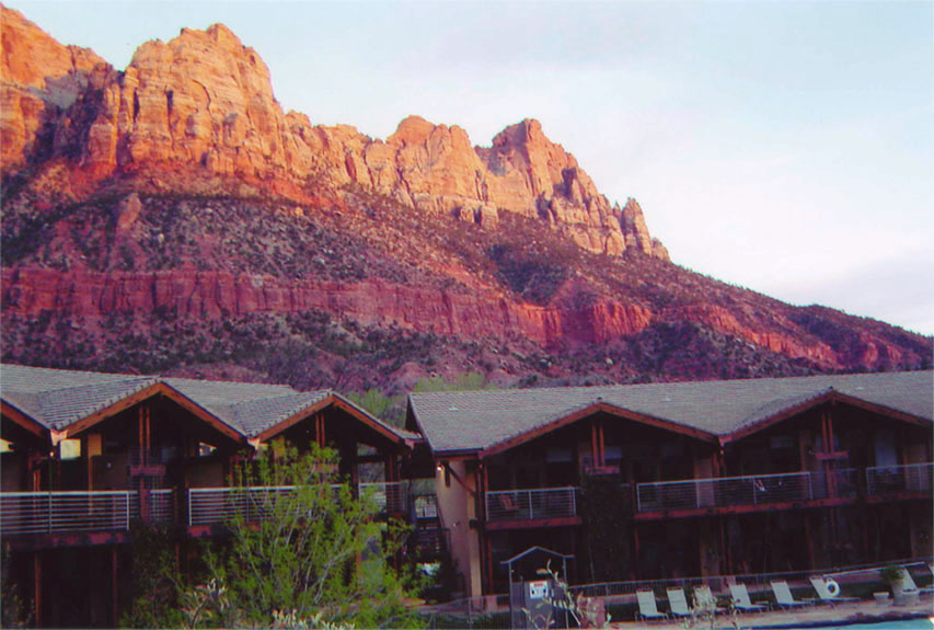
Zion National Park is my favorite, hands down. We have been there over and over. We have hiked end to end, climbed its peaks, and waded through its slot canyons. Its red rock is made more brilliant by the Virgin river and green trees. The proximity to the town of Springdale with its cold drinks and hot breakfast doesn’t hurt either.
The Desert Pearl, in Springdale. If you are looking for a break from camping, this place is unlikely to disappoint.
Angel’s Landing is its most well known hike. It starts with switchbacks called Walter’s Wiggles. It is well known that I love switch backs for the exercise alone. There is no better way to start the day.
It isn’t until after the switchbacks that this hike really separates itself from the rest. Angel’s landing is no joke in terms of exposure and drop offs.
The trail narrows to one way. There is a chain link railing. You are exposed to the depths of the valley floor, more so in some places than in others.
My first time up Angel’s Landing was with my brother. Making it to the top was a rush. Making it back down alive was even better. The next time was with CD. The rush was not as great but the feeling of relief after was even greater. The third time was with CD again. The steps felt more narrow and the valley floor seemed a bit further than before. With that, I decided that three times up Angel’s Landing is likely enough for me.
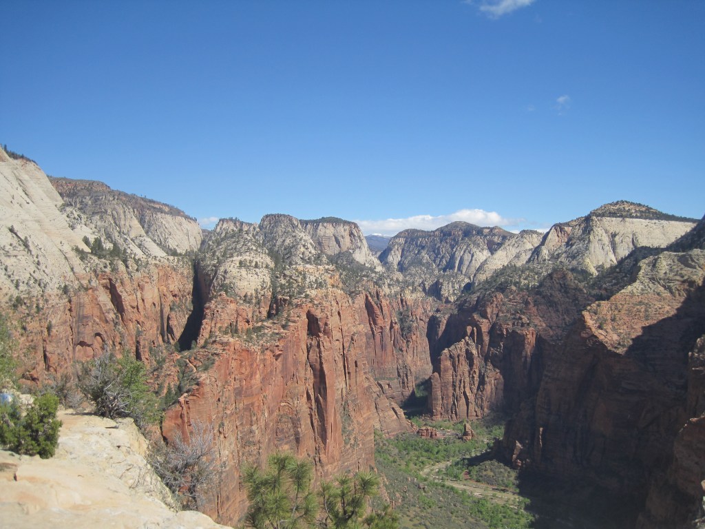
We looked for other routes with bigger and better views. Observation Point hit the mark. It is a more physically challenging and longer hike. It climbs 2100 feet and rises 700 feet above Angel’s Landing.
Back country sites are accessible from the main entrance. Below is the view from our camp site along the West Rim Trail. It is worth noting that we started the hike with a crowd headed to Angel’s Landing. As soon as we turned away from that route, we were on our own. It was super windy and we were surrounded by dead trees. We woke up in the morning to distance runners coming down the rim trail.
Kolob Canyon is Zion’s less known North entrance. It offers day hikes and backpacking trips with few other people around. Our back country site was in an old river bottom. Much of the hiking was in loose sand. Snakes loved it.
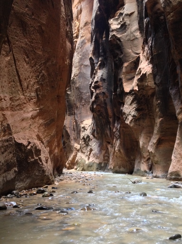
If you have seen the wide open spaces of Zion and are ready for a change, the Narrows may be your next stop. Do your research. Be informed. Watch the weather. These slot canyons are beautiful and it is good to pay attention if you plan to do much exploring. CD met a friend there for his fortieth birthday and they didn’t end up finishing their chosen route because of flash floods.
The Narrows: Zion
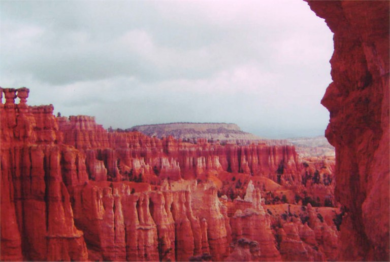
From Zion, you can get to Bryce Canyon in a short day. It is higher and cooler. This is great in the hot months and not as great in the early spring. It is smaller and more compact. The Hoo-doos are unique and impressive. I tend to pass through Bryce westbound to Zion or eastbound to Capital Reef but CD is a fan of the views at sunrise. He also has told me good things about a coin operated shower at the general store.
Apparently, he has a great memory of enjoying a post-hike beer from the general store while sitting on the lodge porch at sunset after a hot shower.
Bryce Canyon
I rarely hear people talk about Capital Reef but we have found it to offer great hiking, impressive rock formations, and amazing views. I don’t recommend hiking there if you are hoping to meet people and chit chat over hand fulls of trail mix. The trails are largely empty.
Capital Reef
At this point it is worth mentioning the San Rafeal Swell. It offers slot canyons with campsites tucked away on BLM land. My advice: Go there, if you have time. Bring your own shade. Do what I did and go with someone that has been there before – hopefully someone proficient at navigating slot canyons. Goblin Valley State Park is near by and may be a better choice if it is your first time in the area.
The price was right but shade was sparse. This was our route to enter the slot canyon.
Canyonlands is easier to access from Moab than from the Southwest. The views are endless. The hiking is interesting and fun. Regions of the park have names like Needles, Island to Sky, and The Maze. Mountain biking the White Rim Road loop is popular and it is on my to-do list for sure. We have not camped in the back country but we have camped just outside the park and there are beautiful starry skies.
Canyonlands
Arches is a straight shot from I-70 and is complimented by it’s close relationship with Moab. The Colorado River provides contrast to the red rock backdrop. The La Salle mountains rise up with snowy peaks and provide further contrast and depth to the scenery.
Moab is like the old west meeting a trendy art gallery. The restaurants and shops are full of personality and there are tour companies to suite everyone’s needs. You can sign up for 4 x 4 tours, mountain biking, hiking, river rafting, paddle boarding, horse back riding, and pretty much anything else you can imagine.
While I cannot speak to the tour companies, I can attest to the hiking and camping. Hikes range from easy to more difficult. Arches is typically one of the more crowded Utah parks but for good reasons. Campsites are dotted along the river banks and range from rustic and isolated to developed and popular. I recommend them all!
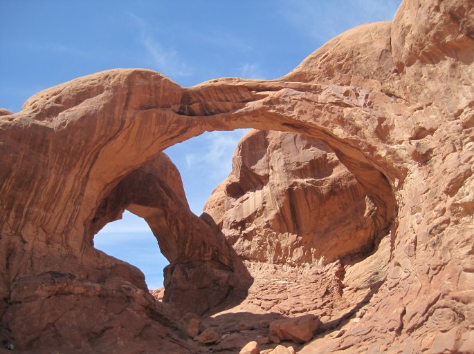
Double Arch
Just a bit East and on BLM land, you can find Castleton.
Castleton Tower from above the parking lot
Pretty much everyone was there to climb. CD climbed with friends while I hiked and then read a book at the campsite. It was great. Everyone was happy.
Hiking up to start the climb. It looked taller in person. This is where I turned around and CD went upOur tent – in the shade!
If you don’t climb, it is still beautiful to see but you will likely enjoy camping somewhere else more than camping here. This was packed with climbers and surrounded by wide open desert.
Dropping down to the four corners, you can hop into Mesa Verde. While the cliff dwellings are interesting and worth seeing, you may find a bit of crowd. My favorite feature is its proximity to Durango. Check out the Silverton Narrow Gauge railway and head North to Ouray or East towards Pagosa Springs on your way out of town.
These petroglyphs are at Mesa Verde. You can see similar markings along I-70 just West of 191.
I could keep going on and on about Utah but will stop myself here for now. Utah is dense with natural wonders. I recommend going there and seeing it first hand.
Red rock dust from ten years ago still stains my hiking boots. Seeing it makes me smile.
The first time that I went to New Mexico, I was in my fifth year of college. I drove from Buffalo to Chicago, flew to Albuquerque, spent a week hiking and camping, flew back to Chicago, drove to West Palm Beach for spring break, and drove back to Buffalo. I can’t really explain the itinerary but must have made sense to my twenty something self.
In any case, that was also the first time I was enchanted by New Mexico. Started in Santa Fe on a warm and sunny spring day, three of us stood on a street corner without talking or crossing the street. We just stood there for seconds or minutes. There were many colors to see, people to watch, and so much energy.
At a hot springs in the Gila National Forest two of us walked back to the car ahead of the others. Through a window crack, we unlocked the door and set off our car alarm. The canyon echoed with the alarm as the sun was setting in the canyon. It continued until our travel partners hiked out and gave us the keys.
Truth or Consequences local convenience store offered soda and a pay phone. My parents were excited for our call and asked if we heard about the woman that escaped a kidnapper in the same town that day. We didn’t see anything unusual and hadn’t watched the news.
Crossing into Texas, we hiked Guadalupe Peak at sunrise. Forgetting sun screen, we ended up with the remarkable sunburns of tourist. Skunks woke us up at night as a mother and her liter spent some time ransacking our campsite. Disaster was narrowly averted.
The Trinity Site wasn’t even on my radar but we found ourselves there on a random day that was open for tours. I learned more than I wanted to know and left with more questions than answers.
Fast forward a few years to me living in Summit County, Colorado. We enjoyed several mud season weekends at La Posada and indulged in all the resort had to offer. We drank wine and shared appetizers with other guests while local artists gave guided tours of their work. The Tunnel of Trees from Northern Michigan was my favorite painting. Proximity to restaurants, art galleries, hiking, and my all time favorite consignment store are the best features of La Posada.
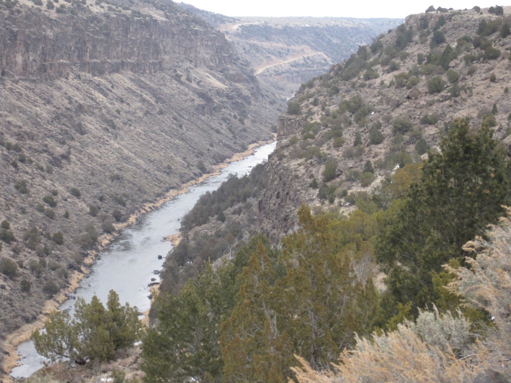
Since New Mexico consistently treated us well, we tossed Taos out as an option for our annual friends ski trip. The opportunity to check out the Earthships tipped the scale and we headed to Taos.
We stayed at the Burch Street Casitas. They offered a great downtown location, were locally owned, clean, and spacious. I would stay there again for sure.
Taos and Green chili
We took advantage of being able to walk to town by immersing in the local food scene. Our meals looked like this: Green chili beer, green chili bread, fried green chiles, green chili smothered burritos, pork green chili, vegetarian green chili, fresh lime margaritas, wine tequila margaritas, more green chili beer …
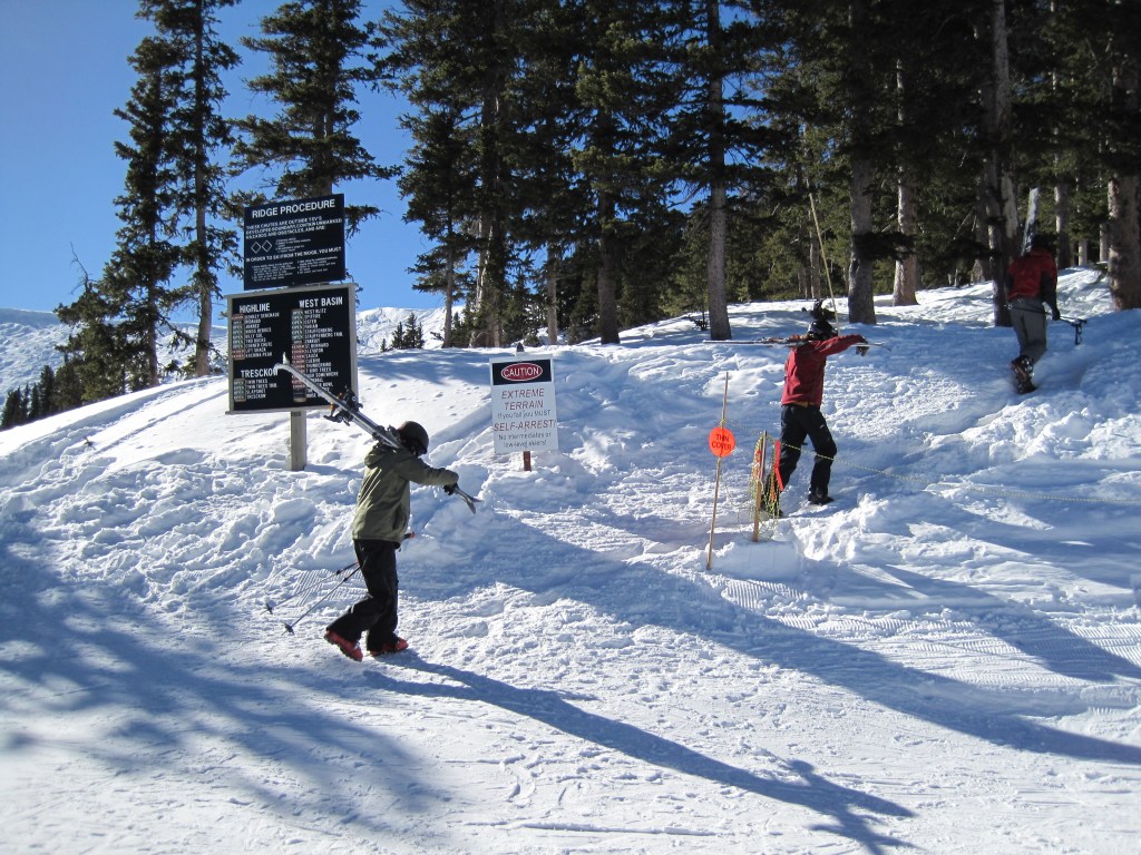
The drive to the ski area was easy and relatively brief. The skiing was good – I think – or at least the hiking and skiing was nice. The wagon shuttle service from the parking lot to the base area was a bonus.
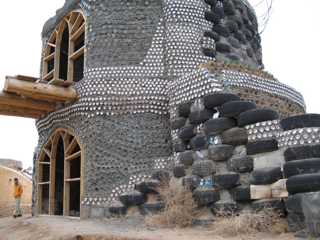
The next day was cloudy and we were lazy. We looked to the Earthships for inspiration.
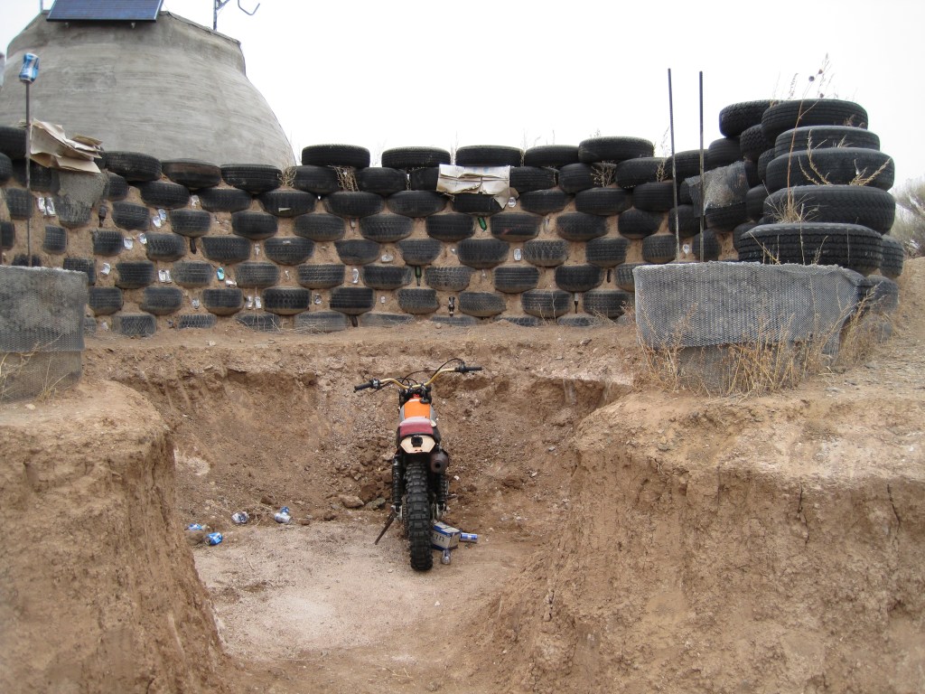
Earthships are built with natural and repurposed materials. You really need to go there to understand the architecture and commitment to sustainability. The tour left a bit to be desired but the purpose of the community was obvious. I felt equally inspired and conflicted.
A wall built with glass bottles. https://www.earthshipglobal.com/visit-us Tires were a common building material. I not sure how I feel about living in a building made of tires, however.
The next day, on the way out of town, a friend wanted to buy some green chiles. CD asked the gas station attendant. An unusually long amount of time passed and he returned confused and empty handed. He had asked about buying green chilies and was offered a hook up of the family stash. In the end, he was pretty sure he was not longer buying green chilies and he walked away from the deal. We left empty handed, conflicted about living in an Earthship, and still loving New Mexico.